WATERFORD
city is situated on the river Suir [pronounced Shure] about seventeen miles from
where the
river
enters the sea. The only thing that distinguishes this first abatement is the
inadequacy of the word 'situated'.
In
design almost fanlike, practically the entire city is built on the
south
bank of the river. The Old Town now the business
centre, clusters behind the broad quay-front on a low-lying strip of land left
behind by a gentle loop of the river at this point. From
this, the land rises sharply to the east and opposite to the west while
remaining level in between. The
eastern slopes are almost entirely occupied by private residential estates,
while the western and southwestern prominences are largely given over to local
authority housing development. There
are corresponding elevations on the north bank eastwards towards Christendom and
westwards towards Mount Misery.
It
is from this latter point—high above the Suir, upstream from the river
bridge—that the city and its setting may best be observed. Here,
the heights on both sides of the Suir persist to the very banks, with the result
that the river courses for a short distance between towering cliffs before
emerging to sweep in one majestic reach past the city. Where
it goes by Waterford, the Suir is as wide as the Thames at Westminster Bridge,
the Vistula at Warsaw or the Neva at St. Petersburg; it is three times the width
of the Tiber at Rome, the Seine at Paris or the Mansanares at Madrid: and five
times the width of the Liffey at O'Connell Bridge.
It
is not surprising then that it is from the river that Waterford gets its civic
character. From our observation
point the spacious mile-long quays extend in an unbroken line eastwards. The
broad quays of Waterford have attracted attention since they were opened up to
the present length 300 years ago by the Corporation. Behind
the tall quayside buildings the city's steeples and towers rise in picturesque
irregularity presenting a picture typical of the older towns, in which ground
contours dictated the layout of the earlier streets. This
gradually gives way to the more regular development of later years fringing the
city on all sides. Such are the
elements forming a city that the natives are reputed to be slow to leave without
a struggle. But history credits
Waterford men with more attributes than a reluctance to leave their native city. In
the middle of the 15th century the citizens were reported to be 'heedy and wary
in public affairs, slow in determining matters of weight, and loving to look ere
they leap.' The Irish word
'faid-ceannnac' has been applied to them too. This
has been translated ‘long-headed’ with more zeal than accuracy; it really
means far-sighted.' Charles I found
the people of Waterford “endowed with good learning and generous
manners." A present day writer
found in Waterford "an air of quiet" and "a sense of
proportion" and described the people as being "undemonstrative" He
added "they do not lack
intelligence or amiability, they just have them implicit."
This
traditional reticence and absence of flamboyance in the Waterford character has
been responsible for the phenomenon perhaps peculiar to Waterford, of the
occasional emergence before the citizenry of vociferous prophets having their
origin outside the bounds of the city. Their
aim has been to insinuate that their superiority over the natives in all matters
is in direct ratio to the relative degree of clamour created by each; the which
of course has no basis in fact and is merely an optical—or more correctly—an
acoustical illusion.
FOUNDATION:
OUTLINE OF DEVELOPMENT.
The foundation of Waterford is claimed in some quarters to have taken place late
in prehistoric times. Other writers
place the event about the middle of the second century. However,
it is difficult to go along any distance with either theory on the strength of
the supporting evidence quoted. At
any rate the antiquity of the place where Waterford now stands cannot be traced
with any satisfactory degree of certainty beyond about 850 A.D. when the site
was occupied and fortified by Sitric the Dane
The
inhabitants of this part of Ireland in pre-Danish times were a pastoral people
moving from place to place with their flocks or else given to hunting. They
did not build towns, unless we admit as towns the settlements that sometimes
sprang up in the neighbourhood of Monasteries. They
certainly did not build sea-ports, and it was as a sea-port that Waterford had
its beginning.
The
Ostmen or Danes as they are more commonly called, persuaded by the rigours of
their own inhospitable clime, had taken to the high seas in search of plunder. During
the first half of the ninth century the shores of south-east Ireland were
ravaged time after time by Danish expeditions, Ardmore and Lismore being the
subjects of a number of raids. At
the outset, these bellicose incursions took place only during the summer months,
the raiders returning home with their spoils at the onset of winter. About
853 A.D., however, Sitric, the Danish chieftain, settled at Waterford and set up
a fortified encampment. A number of factors influenced the choice of the site. The
place provided a splendid anchorage. It
was the lowest point at which the river could at that time be forded. Above
all, the site could easily be defended. It
was protected on three sides by water; in front by the Suir; on the east and at
rear by St. John's River and the marshes flanking it. St.
John's River did not then, as now, flow neatly between regular banks.
Rather, its tortuous and uncontained stream meandered over much of the
ground now occupied by Lombard Street, William Street, the People's Park,
Catherine Street, and Parnell Street, turning this entire area into viscous
marshland. These marshes also
extended westwards round the back of the site of the old town. Only
on the west itself were substantial fortifications necessary.
This
was Waterford in its infancy, a Danish stronghold, subject to constant
harassment by the Irish outside the walls, who broke in on more than one
occasion to lay waste the foreign colony.
The
next phase in the life of Waterford began on August 25th, 1170 when
the town was taken by the Normans under Strongbow. The
Normans had been casting eyes in this direction for some time prior, until
MacMurrough’s invitation gave them cause for coming. Henry
II arrived in Waterford the following year to keep the expeditionary chiefs in
line and receive their homage. The
next royal visitor, in 1185, was prince John, who granted the city's first
Charter in 1205 thus starting City Government in
Waterford. He revisited the city as king in 1211.
Richard II, too, visited Waterford twice, first in 1394 and again in 1399
In
l487 the city refused to obey the direction of the Earl of Kildare to recognise
Lambert Simnel as king and ten years later repulsed a second pretender, Perkin
Warbeck. It was as a result of this
latter engagement that Waterford became known as the Urbs
Intacta a title conferred by Henry II. Printing
was introduced into Waterford in 1550, the first book being printed in the city
five years later.
It
was in 1588 that Duncannon was fortified as a precaution against Spanish attacks
along the coast, which were being experienced at the time
Waterford
was occupied by Mountjoy in 1603 and visited by Rinuccini in 1648. The
latter, in his Report on the Affairs of Ireland sent to Pope Innocent X,
described Waterford as being "one of the only two Irish cities he would
place in the front rank for reverence to the Holy See." In
l649, the city was unsuccessfully besieged by Cromwell, but was forced to
surrender to his Deputy, Ireton, in the summer of the following year. After
the Battle of the Boyne, both James and William came by Waterford, James on his
way to France and William returning to England. It
was soon after this, about 1700, that the Huguenots came to Waterford.
There
was no armed uprising in the neighbourhood as part of the 1798 rebellion, the
probability of such being set aside by the defeat at Wexford. There
was, however, considerable United Ireland activity in the city and district,
where secret recruitment had been going on apace. Among
those arraigned for seditious activity at the time was the toll collector of the
then five-year-old wooden bridge.
In
l826, Waterford returned Villiers Stuart to parliament against the opposition of
Lord George Beresford, the outgoing candidate and powerful landowner in the
district. Stuart was put forward by
Daniel O'Connell's Catholic Association and O'Connell personally led his
campaign here. Though not a Catholic
himself, Stuart was a man of liberal views and his election was an important
step in the way to Catholic Emancipation which came three years later.
The
Great Faminc of 1846-48 made itself felt in the city and the Corporation records
of the period refer to several money grants to relieve the distress of the
people.
The fact that there were large quantities of rice in Waterford, saved the
city from the worst effects of disastrous shortage in their normal food supply.
AREA
AND EXTENT: THE CITY WALLS.
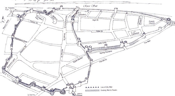
There
is no record of the extent of any settlement that may have existed at Waterford
prior to the middle of the 9th century. The
Danish colony founded about that time (853 A.D.) was triangular in shape and
contained 15 acres approximately. This area was enclosed by stout ramparts
linking Reginald's Tower with St. Martin's Castle (site in Spring Garden Alley);
from thence running to Turgesius' Tower, which stood in the immediate vicinity
of the Allied Irish Bank (corner of Barronstrand St.) and returning along the
river-front to Reginald's Tower.
Substantial
remains of the wall in the 500 metre stretch between Reginald's Tower and St.
Martin's Castle still exist, except where broken by the erection of the City
Hall and the opening of Colbeck Street (former (Colbeck Gate). These
traces may be observed between the houses of the Mall and Bailey's New Street
and, further up, between Spring Garden Alley and Lady Lane, about 12 metres back
from the northern frontage of the former. In
the old handball alley, some four metres of the Wall—in places six metres
high—stand exposed. Also, parts of
the breastwork of St. Martin's Castle have been incorporated in the foundations
and lower courses of the buildings that now stand on its former site.
There
are a few traces at the wall linking St. Martin's Castle with Turgesius' Tower,
and which followed the line of Michael Street and Broad Street, about sixteen to
twenty metres back from the present eastern frontage of these streets.
The
wall fronting the Quay has completely disappeared. It
was demolished and the material thrown down to form the foundation of the
present Quays, partly under the Cromwellian Commissioners in 1650 and totally by
the Corporation of 1705, which improved and enlarged the Quays.